Rucu Pichincha

 And here´s the view without the people. This is the view to the south, and below is the view to the north. Quito is a very long city built alongside the Andes. Everything north of the Virgin is considered north, and vice versa.
 So I had the bright idea of hiking to Rucu Pichincha, where you can peer into the volcano´s crater. The summit of Ruch Pichincha is 4680m, so it´s a 580m hike to the top. Sound ok right? Well, no. Take into account it was a 580m ascent, the low oxygen levels at higher altitudes, and the fact that I had a blocked nose, it was not a good combination. I was generally unfit anyway, which did not help. It was 10 times harder than the walk in Baños! The walk alternated from very steep to steep to uphill slope. I had to take rest stops every few metres, but at least I could appreciate the view while I waited for my breathe to catch up. The other 2 ended up being about 15 minutes ahead of me. Luckily I eventually caught up (they stopped to rest), because after that point it was even harder. We had to boulder across some rocks (almost a cliff face), after which we hit sand. The sand was as thick as that on the beach, except softer, so our feet kept sinking. Plus it was an uphill climb. I gave up walking at that stage. I was almost on all fours trying to scramble up the slope. We got up in the end, and we reached a point where we could see most of the view. The path ahead was all sand (the same scrambling type, which would continue for another hour or so, according to an american guy we walked past), so I suggested we stop there and walk back. Thankfully, the others agreed. I think we got to the base of the summit, if that makes sense. In other words, we got to the base of the crater.
I managed to take my hands out of my pockets to take some photos in order to commemorate the hike. It was absolutely FREEZING up there! I can´t believe the other 2 had considered wearing shorts! I told them it was going to be cold at 4500m (from the Tasmanian experience, which wasn´t that high, I think, but was alpine nonetheless!!).

We were above the clouds! It was amazing!


Obviously, you had to be there. A camera will never do the vistas any justice. But it can try...below is the path. It´s rather rugged. And you can see how far we walked. Actually you can´t. You can´t even see where we started from, it´s too far, and hidden by the mountain. Take my word for it, it was far. It took us 3 hours to hike up, and 2 hours to slide down.

You can see the path slightly better in the photo below. And a bit of the sandy bit we had to scramble up. This photo was taken where we eventually stopped.

Here´s Rucu Pichincha from the Teleferiqo station (at 4100m). I can´t believe we walked so far. 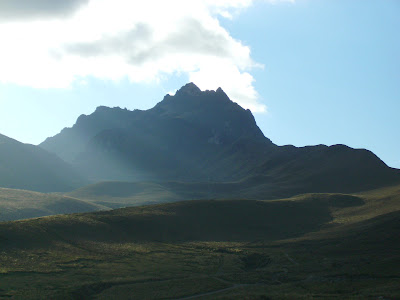 Needless to say, when we got back to the Teleferiqo, we were completely exhausted, and my feet were killing me! They were getting blistered because as we were running downhill (it was too steep to walk), my toes were being pushed to the ends of my shoes, and were rubbing against it. In the end, it got painful to walk. No wonder, because when I took my boots off, I found that the skin had been rubbed off my toe! Ugh! Here´s the photo. I had to commemorate that too! Thank you Stacy for the med kit. I needed the band aid and alcohol swab!
 Oh, before I go, I have to say, on our hike up, we met an old couple, (74 and 80 years old), and they hike up everyday! I don´t know how far they go (probably not to the sandy, scrambling part), but that is seriously impressive! It´s quite humbling. I was all puffed out, and they seemed like they were totally fine! Granted they were walking slowly, but at that age, it´s pretty cool to still be walking without assistance, let alone hiking up a friggin volcano above 4100m!
Labels: Pichincha
posted by Ruiyi @ 11:25 AM
![]()
![]()

2 Comments:
Hmmm I wonder if my post will work this time? It sounds as if you're having so much fun in Quito. I especially liked the contrast between colonial Quito and the vistas of that place you hiked up. It sounds like such a relaxing a carefree way of holidaying - perhaps I should do that sometime. Holidays should really be relaxing affairs rather than the monopoly-board-type of holiday. After all, one only has so few days off a year, and it would be a pity to spend it being flustered going from street corner to street corner with an indecipherable map. But enough philosophising - Quito looks like a large country town! I thought South America was very overpopulated, but you wouldn't have thought that of Quito. There are no skyscrapers, the square was relatively empty, and it just seems completely devoid of a ratrace. What a wonderful place in which to contemplate about life, liberty and the pursuit of happiness. Well done on your hike; but was it REALLY necessary to publish a photo of your blister?! Ugh shudder! Oh btw, perhaps you could publish something about the toilet situation in Quito. Squatting or sitting? Do you have to pay? Or have you been holding it in until you get to a rich Western hotel with besuited attendants giving hot towels at the close of one's business? Enough procrastination; back to study! PS - I agree with your coriolis effect theory. 2 metres south/north of the equator seems far too marginal. And in any case, did the demonstrator ask people to pour in the water themselves? Had he/she done so, the credibility of the experiment would have increased by a not insignificant margin!
hi ruiyi,
the last time i tried to look at your blog my computer went kaput (un-useable pc's is a recurring event for me). anyways so i'm just seeing all your photo's now, and slowly getting jelous with each page!
from your writing its not hard to tell your a greenie. damed rivers, soil fertility, pollution and the corriolis effect ha ha! i might have to try your ginger tea idea. did you get through it all?
i understand the difficulty of climbing the mountain. recently in sabah i climbed mt kinabalu - 4ks and a bit. so i don't think you are joking when you say you had to stop for breath every few meters at the top. i know it did! and yes seeing grannies overtake you just doesn't feel right.
hope your feeling better.
stefanie
Post a Comment
Subscribe to Post Comments [Atom]
<< Home